Showing all posts tagged location-services:

Hyperlocation, A New Era of Location Services


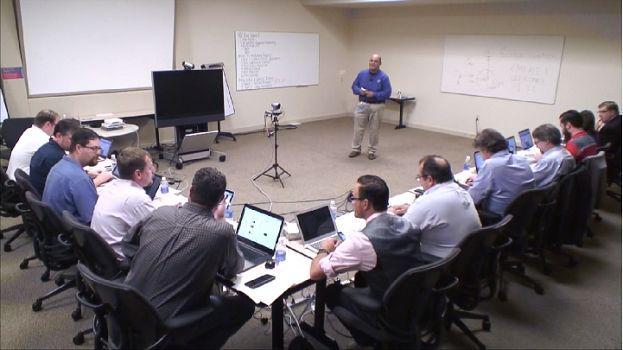
I had the opportunity this week to visit Cisco Systems with the the Wireless Field Day 8 crew this past week to discuss the updates to the Cisco location services roadmap. This space has been a passion of mine for a number of years and to see major advances in the last 12-18 months has really gotten me energized again about the possibilities that are out there.


Cisco provided a recap of how we got to where we are today and I wanted to do the same to ensure that the concepts here are captured properly.
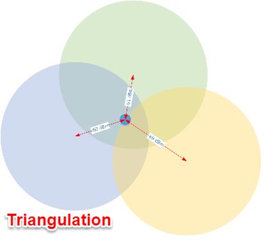
Triangulation
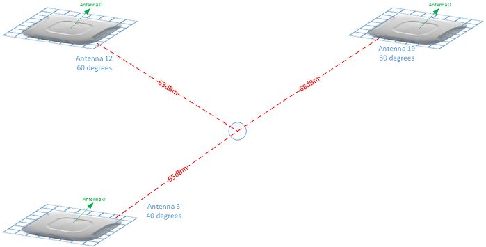
Location services use the triangulation concept to position a device within some probability of accuracy. In the example below, the object being tracked is roughly equidistant from the access points in the upper and left access points and a bit further from the right access point. As you may already know, under most conditions the best accuracy that can be expected is 3-5 meters and there is no certainty that the tracked client will be in a specific room as it could be on the other side of a wall, etc. This has lead to minimal adoption of location services as often this information simply isn't good enough to be useful. It's also important to note as Cisco mentioned in their discussion that for a packet to be seen by all three APs in this scenario, it must be a broadcast packet. On many devices, broadcast packets are becoming more uncommon while associated to an access point. This means that the refresh rate of this location information is slowing down, decreasing its usefulness further.
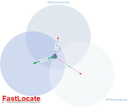

FastLocate
One of Cisco's recent innovations to assist this refresh rate issue is known as FastLocate. This uses data packets to improve the rate at which we see packets. Since data packets only exist between the client and the AP that it is associated (green arrow in the FastLocate diagram), the other APs have to go off-channel briefly to hear these packets as well. This process improves the refresh rate from approximately 1 frame per 60 seconds to 1 frame per 10 seconds. It's important to note that while this does not improve the actual location measurements, it does provide more data points which allows for better overall resolution and causes less "jumping" in which clients appear to teleport from one location to another.


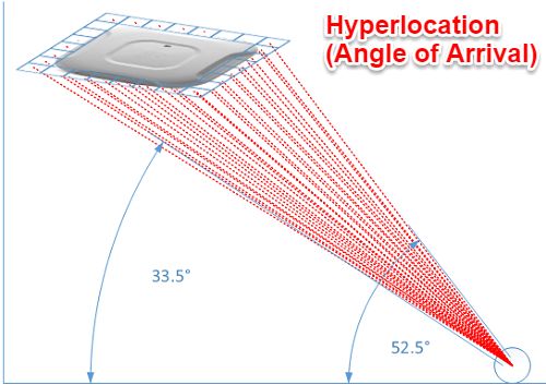
Cisco's Hyperlocation Module (HALO)
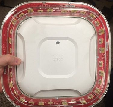
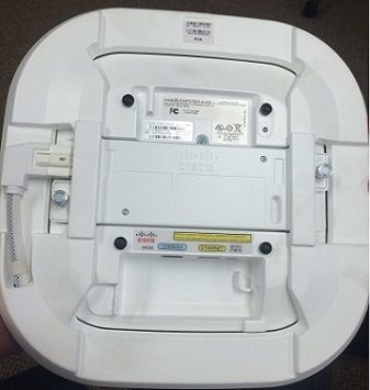
The HALO module was the highlight of the Cisco presentation for me as I had not seen one of these up close yet. The HALO module leverages a 32 element (16 2.4GHz and 32 dual-band 2.4/5GHz) phased array antenna that sits on a collar surrounding the access point and attaches via a special connector on the new wireless security module. This array is comprised of directional antennas which enables far greater location accuracy and is truly the first real leap in wireless location accuracy in quite some time. Since each of these antennas are facing different directions and are all slightly located apart from each other, it is possible for the APs to calculate Angle of Arrival (AoA) in the wireless signal. This combined with the traditional triangulation allows for very specific accuracy down to approximately 1 meter, which is competitive with BLE capabilities. Further testing will be required to see if these claims hold up and if we can see actual room level (or better yet bed, etc.) accuracy, but I believe strongly that this will be the case in most situations. Currently this limited to associated clients only, but there is a near term roadmap for products that beacon on regular intervals such as RTLS tags. Tracking unassociated devices is of lesser priority right now, but is on the road map.


Halo to Usher in a New Era of Location Services for Healthcare
Enabling an infrastructure with serious location capabilities isn't cheap at roughly $1000 per access point (MSRP), so the use cases need to be substantial. HALO is a premium engagement and location offering that will not be adopted by the masses, however those who can leverage it effectively stand to offer tremendous value to their customers, patients, stakeholders, etc. Hospital environments to be the single most valuable environment for HALO, especially after RTLS tags are added to the mix. This environment is highly mobile and ripe for disruptive location technologies that can automate work flow and enable meaningful interactions and engagement. Hospitals today leverage multiple location systems that facilitate portions of work flow, however very infrequently are they integrated together well enough to gain additional actionable insights. There are a number of point products addressing nurse rounding, locating wheelchairs and beds, theft prevention (babies and assets), etc. Some of the "bleeding edge" use cases include playing a loved one's voice over IP speakers to coax an elderly patient back into bed or having a display cheer up a child who is battling cancer when they near the screen. In theory, this HALO module is enabling a world in which we know where every associated wireless device is down to a matter of feet, without necessitating RTLS tags. This opens the data floodgates for actionable intelligence at unprecedented levels.

Work Flow Optimization
RTLS vendors have been selling their solutions for years to address these issues and while there are clear ROIs in most cases, it still doesn't get adopted due to significant cost and/or limitations for a single purpose system. HALO offers the ability to gain insight into numerous inefficiencies within a hospital and can improve any investment already made in tags and RTLS systems. More importantly a truly location-enabled work flow could facilitate meaningful interruption ensuring that nurses are only getting notifications when absolutely necessary and routing other requests to someone who is better positioned to assist a patient quickly. These use cases have been well defined over the years and HALO is an enabler to making these a reality.

Throughput Analytics
Integrated with Prime and the MSE, HALO can provide improved throughput analytics for the waiting rooms. I'd expect this to get down to individual care arcs in which an organization could track a single patient progressing through their visit and providing trends. This would provide feedback into the work flow optimization process and enable further analysis of the changes made to the work flow processes.

Patient Engagement
There has been a lot of buzz around "mobile engagement" lately and as a professional in this field I can attest that there certainly are many options and the jury is out as to which is the best one at this point. I am a huge proponent of the Low-Energy Bluetooth solutions out there, however HALO may be the first "Wi-Fi only" offering that offers the ability to truly engage with BLE-like location capabilities. Organizations evaluating these solutions need to account for the care and feeding of a BLE-based solution as like many of the RTLS offerings there is a battery powered infrastructure that has to be maintained.

Turning Low-Energy Bluetooth (BLE) Upside Down
One of the major limitations to the Low-Energy Bluetooth solutions is that they are almost exactly backwards from RTLS solutions in that mobile assets are required to interact with fixed (usually) assets. This typically means an app on a Smartphone (carried by a mobile user) is the typical mode of engagement and this is an active process. A few use cases of cropped up recently in which a BLE-beacon is strapped to a patient to monitor them as they move through an environment. To accomplish this the interaction points along the way require a tablet mounted to the wall to pick up on the patient's tag and initiate the engagement work flow. This reverse BLE-solution is somewhat innovative and solves a specific problem, however we need a world in which mobile assets are interacting with other assets on demand and relative proximity to each other should be irrelevant as long as I have access to the back end data. I believe that HALO is positioned to do exactly this as it evolves and in doing so will allow the use of Wi-Fi based geofencing capabilities indoor, reducing or possibly even eliminating the need for traditional fixed beacons. At the very least this will provide us new deployment options and can be combined with a BLE infrastructure to offer infinite interaction capabilities.

Internet of Things
The items above all point towards enabling the Internet of Things (IoT) and allowing real time interactions between devices to the betterment of the healthcare environment. An example of this could be the lifecycle of an infusion pump. These devices follow a predictable cycle in which they move from being clean through being attached to a patient and ultimately wind up having to be cleaned again before being released back to the care areas. In this scenario, alarms could be triggered by a device that has not been put in a maintenance mode and is following an unexpected path, possibly avoiding a dirty pump being brought to a patient, etc.

Using HALO
Effectively using HALO requires that the APs are mounted to the ceiling grid as they need clear line of sight. Density is expected to be at least one AP every 50' with each covering roughly 2500 square feet. Environments using smartphones, etc. will typically see smaller square footages per AP due to the requirements of those smartphones, so the density of these modules will be higher.

Installations are expected to take longer due to specific needs around mounting locations. X,Y,Z coordinates need to be exact as well as the HALO module rotational orientation and alignment with antenna 0 of the 32 element array. These positions must be set in Prime 3.0 to provide proper location capabilities.


HALO Requirements
Cisco 3600/3700 AP (and future access points)
Cisco Wireless LAN Controller running 8.1 MR3 (8.1.123.x)
Cisco Prime 3.0
Cisco Mobility Services Engine
Cisco Connected Mobile Experience (CMX) 10.2.1


Google's Eddystone-Updating the Physical Web


Much ado has been made about the Apple iBeacon over the past couple of years with market analysts predicting a rise from $4B to $44B in iBeacon influenced sales. Outside of retail, some interesting use cases have cropped up and have been tested, however mainstream adoption for other verticals isn't there yet. Enter Apple's archrival Google with their Eddystone, an open-source, cross-platform low energy bluetooth (BLE) beacon. The open nature of the Google Eddystone and its ability to broadcast a URL offers some new and interesting use cases, especially since it no longer requires a mobile app. The requirement for a mobile app is the single largest hurdle to adoption of any beacon strategy as it requires end-users to opt in to using a company's solution in a major way. The upfront cost of a mobile app and often lack of understanding around mobile app strategy scares some companies away from attempting this and impedes the overall growth of the solution. Every conversation that I have had around iBeacon solutions to-date involves customer education around what is and is not possible and the level of effort required to make some things work.

What is Different?
Designed to be cross-platform, Google's Eddystone supports the Nearby API and is available on GitHub under Apache 2.0 license.

The Infobubble
Anyone interested in creating awareness of who they are, what they are doing, or empowering a device to do the same in a given location now has the ability to advertise to passersby. This has many implications from brand awareness to interacting with a specific device. Most importantly this can happen on the smallest of scales, increasing the chance for adoption and interaction since there is no dependency on a mobile app. Check out the Physical Web Cookbook for many newer ideas.

Multiple Frame Types
Google Eddystone supports multiple frame types enabling users to interact in a variety of ways. These frames are designated in the Service Data field associated with the Service UUID by using the high order four bits of the first octet. Github provides all this information in much more depth.

Frame Type
High-Order 4 Bits
Low-Order 4 Bits
(Reserved for Future Use)
Byte Value
Unique Identifier (UID)
0000
0000
0x00
Uniform Resource Locator (URL)
0001
0000
0x10
Telemetry Data (TLM)
0002
0000
0x20


Universally Unique Identifier (UUID)
If this sounds familiar, it is because it is the same type of identifier that iBeacons use. Google implemented the same 128-bit value that enables applications and specific use cases using major and minor numbers. This form of interaction is tied to a specific app and as such is limited to users who have that specific app installed.

URLs
The implementation of URL broadcast is meant to address the issues in which users aren't so interested in installing an app and caters to a "one-time use" scenario. This powerful option can provide a user with information through a standard web browser, ensuring that all users have access to this data. Effectively this URL broadcast could replace every instance of a QR code with the added benefit of not actually having to take a picture of the QR code, this data can just be available over the air.

Ephemeral Identifiers (EIDs)
A secured identifier that only permits authorized access. A 10-byte namespace is used to ensure uniqueness across multiple Eddystone implementations. Security is achieved using a truncated hash of a fully qualified domain name (FQDN) or an elided version 4 UUID which involves removing some information from the UUID.

Telemetry Data
Diagnostic data enabling an organization to better manage their beacon infrastructure. This includes battery life and other critical info. It is important to know that this type of information must be paired with either EID or URL since it does not contain a beacon ID. Telemetry data may include battery voltage, beacon temperature, advertising PDU count, and uptime.

Eddystone Ecosystem

Nearby API

Proximity Beacon API
The Proximity Beacon API is a new interface enabling users to manage their beacons via the cloud and use a REST interface. This enables monitoring of the telemetry data previously mentioned as well as reconfiguration of the beacons.

BKON Eddystone
I opted for the BKON Eddystones to try, there are a few options out there, but I liked the approach and packaging that I saw on the BKON site and acquired them through Amazon (2 for $60). AAA batteries were included and already installed. Also included a screwdriver and 3M dual-sided sticky tape. One thing I am not a fan of is the lack of screw type mounts as seen on the Aruba beacons. I'm not convinced the 3M sticky tape will hold up as long as a battery will, especially for beacons in tougher climates--outdoors, fridge/freezer, high humidity, etc. That being said though, the overall packaging and included items are great!

PHY.Net
Setting up with PHY.net was painless, simple field with beacon ID (located on side of beacon), valid email address and contact info. BKON sends a validation email to confirm.


Browsing...and a surprise
As of right now a specific browser is needed to browse the Physical Web. The screenshot to the right is from BKON's own "BeaconPages" available for IOS. Alternatively, you can install "Physical Web" available on both IOS and Android. I found it interesting that this Physical Web app picked up my HP printer via Bluetooth and let me view the configuration page. Interestingly, the Bluetooth radio is configured as "off" on the HP printer. I could pull my MAC and IP addresses, subnet mask, gateway, DNS info and host names via the Physical Web browser. I would have to log in to the printer to change any settings, but I was still surprised at how much information was readily available. Perhaps the next blog post will be on security.....


Building a Contextually Aware Network: Geolocation (Part 2 of 4)

Overview

Geolocation is defined as the process of physically locating or the actual location of an object on Earth. In defining contextually aware networks, it is no longer enough to know whether someone is on-net or off-net. Where they are "off network" is important as well and can offer additional insights and opportunities for engagement.

Geolocation Technical Details

Geolocation primarily leverages a Smartphone's built in Global Positioning System (GPS) and uses the installed application and either Wi-Fi or cellular backhaul to report current location for users that have opted in to this offering. This enables the operator of a contextually aware application to engage with the customer outside the "four walls" of the organization. At this macro scale, location is typically measured in meters however results vary wildly depending on the type of location being deployed.

Assisted GPS (A-GPS)

Assisted GPS uses a secondary system to increase the accuracy of the GPS satellite reporting. In the case of Smartphones the cellular network is responsible for assisting. This enables the phone to download information about the GPS satellites in order to quickly determine its position and provide updates at an interval frequent enough to be useful for engagement purposes. The newest smartphones are able to use both the US Department of Defense GPS system and the Russian GLONASS system to further increase accuracy. These solutions are limited in scope from an engagement perspective as they require clear visibility to the sky, so they tend to not function in large downtown areas. Recent testing has shown that A-GPS offers approximately an 8 meter accuracy range, which is typically accurate enough for any of the geolocation use cases. IT is important to note that accuracy in dense urban centers may still be challenged at times.

Geofencing

One of the most important aspects of constructing a contextually aware network is the concept of geofencing. A geofence is a virtual construct that overlays a logical "fence" on the world map and allows decisions to be made as a device crosses the geofence or is inside or outside that geofence. A virtually unlimited number of geofences can be constructed, but it is important to know when engaging with the customer is meaningful and wanted. Since the geofence is virtual, no equipment is required at any location defined by a geofence.

How Geofencing Works

Let's assume for a moment that you are headed out on a gambling vacation to "The Vegas Hotel" on the south end of the Las Vegas strip and have installed their mobile concierge app. Upon landing at McCarran airport and taking your phone out of airplane mode, it is able to recognize its GPS coordinates via A-GPS and the concierge app wakes up. Once awake, the app prompts you to meet your hotel shuttle outside baggage claim #2. Once you meet your shuttle and arrive at the hotel, you could also cross a geofence. This hotel side geofence lets the hotel know that you have arrived on their property. A property geofence allows for analytics around when customers are on or off property, insights into the shuttle service travel times, etc.


Geoconquesting

Geoconquesting is the ability to leverage geolocation and fencing to pursue those who are patronizing a competitor's location. This information may be used for direct customer engagement via their installed application or indirectly by providing information that can tailor how future marketing is done to sway the customer's future decisions as to where they spend their money and/or time. Let's assume that the "Vegas Hotel" highlighted above is running a strategic marketing campaign to capture more business on the south end of the strip. Geofences could be established around competitors properties for analytics purposes to help an organization better understand how much time their customers are spending on property versus at a competing site. Typically this can then be used to entice users to come back to their establishment.


Closing Thoughts

Geofencing is a very powerful component of context aware networking, however the engagements need to be used sparingly as there are many users who feel this type of engagement could be an invasion of privacy if they weren't expecting to receive messages. There are many use cases for the back end analytics enabled by geofencing from location enabled work flow automation for a mobile fleet to targeted interactions with customers to predicting whether or a patient might arrive for a doctors appointment or not and early adopters of this technology have a distinct competitive advantage versus those who do not have the same capabilities.


Quick Links

Part III: Building a Contextually Aware Network: Analytics (TBD-Mid Jan)
Part IV: Building a Contextually Aware Network: The Big Picture (TBD-Late Jan)